In my previous post, I made my point of the diversity in Mexican electoral preferences across the country. Although I have some experience in the study of demographics across the country, there is no other city that I understand more than Mexico City. I thought it would be interesting to delve deeper into the electoral preferences in this city that is extremely complex starting with the fact that it is split in two different administrative entities. The Federal District has been ruled by the PRD --- the left party --- since 1997 and as I mentioned in my previous post they have done such a good job that they were favored in the presidential election in every single municipality, it is important to remember that Lopez Obrador, the PRD candidate for the presidential election ruled the D.F. from 2000 to 2006. The northern area of the city, the State of Mexico has been ruled by the PRI since there has been democracy in Mexico (around 83 years), and Peña Nieto was the governor from 2005 to 2011.
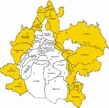 |
| Boundaries between D.F. in white and Estado de Mexico in Yellow |

I downloaded the information from the Preliminary Electoral Results Program that the Federal Electoral Institute provides online to anyone that wishes to download this information. The numbers that I present here are not to be taken as official since they come from this preliminary results system. I focused on the results of the presidential elections because they are they most controversial of elections and the ones where voters are actually familiar with the candidates.
I prepared these maps aggregating the results from district level information into municipalities as I was unable to obtain the electoral cartography in time. The first map presents the absolute winner of the elections in each administrative area of Mexico's metropolitan area. You can observe that most of the Federal District plus the municipalities of Izcalli, Coacalco and Cd. Nezahualcoyotl form the State of Mexico favored the PRD candidate while no municipality in D.F. voted for the PRI and most State of Mexico municipalities except the other three did vote for Peña Nieto. It is important to note that the municipalities that did vote for Peña Nieto are very diverse in their demographic information. Naucalpan de Juarez in the center-west is one of the municipalities with highest income per capita in Mexico while Chimahuacan in the extreme East of the city is one of the most densely and poorest municipalities in the urban areas of the country. In the following maps I will try to dis-aggregate the presidential election results to explore on differences in the preferences of the population.
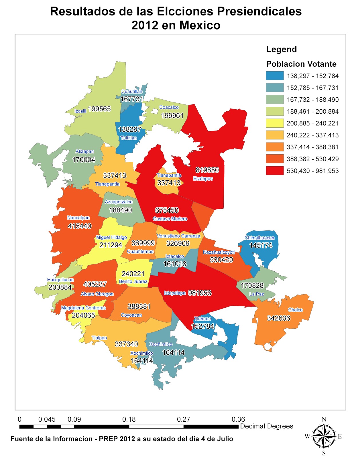
It is important to start with a quick view at the absolute voter numbers. You can observe from the map that winning certain municipalities can be more important in terms of number of votes than others. We should keep in mind these municipalities as we move on with the analysis. Iztapalapa, Gustavo Madero and Ecatepec are the areas with most population, followed by Cd. Nezahualcoyotl, Naucalpan and Alvaro Obregon.
So what can this way of looking at the information add to our current understanding of the city? Taking the boundaries of the city as the definition you can observe in my analysis. The PRD obtained 45.15% of the votes, the PRI 32.7% and the PAN 18.11%. The Partido Nueva Alianza got 2.08% of votes and 1.85% of voters nullified their ballot. All in all 65% of the population in the electoral list went out to vote in what is considered the most participated elections in Mexican democracy. Let's start our exploratory analysis with the PRD.

The most obvious pattern to observe is that municipalities in the Estado de Mexico show a much lower fraction of the votes than within the Distrito Federal even in the municipalities where the PRD was victorious such as Cd. Nezahualcoyotl in the East, let's call this the North-South divide. The second interesting pattern to observe is that there seems to be an West- East Divide thant comes after the North-South divide. Within the D.F. some municipalities voted for the PRD in fraction of more than 51%, Iztapalapa, Gustavo Madero, Tlahuac and Xochimilco while other municipalities in the west of the D.F. received much less votes for the PRD such as Miguel Hidalgo, Cuauhtemoc and Alvaro Obregon. This West- East divide could be related to the huge differences in income per capita in these areas. Further analysis would be required but this is one of my hypothesis. I worked in Car Market analysis and this divide shows the same pattern that the analysis of who buys new cars and who buys used cars. An interesting outlier is the Benito Juarez municipality in the center of the D.F., this area has the highest human development indicator values of the whole country. Only 39 % of votes for the PRD.
This West-East divide is also to be observed in the State of Mexico, Cd. Neza, La Paz, Chalco and Ecatepec gave the PRD 40% of their votes while Naucalpan, Tlanepantla and Atizapan only gave 32%. My hypothesis are similar than previously. But I do want to point out at one thing. How come that in Benito Juarez the PRD only got 39% and yet it won the area and in Chalco and La Paz the PRD got more than 40% and yet loss to the PRI. I hope this seems intriguing to you.
Now the PRI results. They received an average of 32.17%.

I find this map truly flabergasting, I was expecting to see similar results than the ones on the PRD, yet they are extremely different. First things first, the North South divide. Yes there are huge differences between D.F. and State of Mexico, this is familiar territory. But where is your West-East divide? Completely gone... In both the D.F. and the State of Mexico. Naucalpan a very high-income area and Cd. Nezahualcoyotl home to some of Mexico city worse slums gave a very similar amount of votes --- relatively speaking --- to Peña Nieto. In the D.F. Miguel Hidalgo (Polanco is here), Cuauhtemoc (Tepito is here) and Venustiano Carranza (home to the Airport) gave very similar results in terms of PRI fractions. Benito Juarez, Gustavo Madero and Xochimilco gave the same number of votes to the PRI. The only pattern that you might be able to talk about is some sort of North South divide within the D.F. but it is definitely not clear at all. What is true is that Iztapalapa, Coyoacan and Tlalpan are the areas where the PRI scored the lowest and it does not correspond exactly to the areas where the PRD scored highest. We are missing our third runner of the evening.
The PAN, the right wing party, who managed to loose all municipality governments in the D.F. except for Benito Juarez. Some speak that these disastrous results are related to a very poor choice in their candidate for the government of the city. But Politics is for politicians and I am more interested in facts derived from quantitative analysis.

When I first saw this map I actually decided that I had to write this post. I was expecting to see either of the previous two patterns that we observed for the PRD and PRI results, and here a third completely new pattern that actually made sense after a while. The North South divide in the results of the PAN are gone. There is very little difference in the results in the State of Mexico and in the D.F. Miguel Hidalgo, Naucalpan and Atizapan are all around 24%. Iztapalapa and Chalco are both 12%. Ecatepec and Gustavo Madero are close to 15%. What is really striking is the West- East divide that becomes much more noticeable than in the previous maps. Alvaro Obregon and Azcapotzalco who were sort of middle ground in their preferences to the PRD are now clearly similar to their surrounding municipalities. It is important to mention that the North-South divide in the Eastern part of the city does exist. the South East and North East are different in their PAN preferences. Yet the borders between D.F. and State of Mexico appear to have nothing to do with this.
Now these results are basically based on pure observation, they are affected by my own subjectivity and do not look into the statistical significance of the differences I mention. There are better geo-statistical analyses that are much more precise and that would yield more robust results. Nevertheless I could not have released them in such short notice. I do believe that if I performed these analysis such as cluster/hot spot analysis, run a k-means algorithm and check for statistical differences between the resulting areas and of course some local autocorrelation I would be able to support my hypothesis of the existence of this North South and West_East divide that affects differently the three political parties. The reasons for these divides remains to be explained, I believe the West-East divide is related to income while the North South divide has to do with matters related to historical governance.
In case you are interested I present the results for the PANAL a minor party that represents the teacher union which is very strong in Mexico. Here the difference between D.F. and State of Mexico is clearly noticeable. Miguel Hidalgo, Benito Juarez and Coyoacan show particularly low support for the PANAL, it would be interesting to see why that is. My guess: it's related to the number of years of education.

The patterns of vote nullification is unclear, I would throw a huge hypothesis that there are several factors involved, one is the urban rural divide, second is the number of years of schooling and third a sentiment of belief in the Mexican party system.

On participation in the elections, the differences between D.F. and State of Mexico are only noticeable in the East of the city. the West-East divide is again there. I would dare to say that the pattern I observe here is similar to the results of the PAN.

Any suggestions or comments are greatly appreciated.
No hay comentarios:
Publicar un comentario