viernes, 2 de noviembre de 2012

Rapid mobile data collection training with Open Data Kit and Formhub in Liberia

Check the full post - including the amazing pictures - on terra incognita on wordpress. 


This post was originally posted on the Formhub blog in October 2012. I have made some changes to the text and added some pictures of my own.
As a part of the project to support the Liberian government in the preparation of their energy sector Master Plan, Modi’s Lab conducted a two-week training to prepare key government staff from four different Liberian government organizations in the use of mobile rapid data-gathering tools to estimate the urban and rural energy demand in the country. I had the opportunity to join the team to support on this 2-week long training in Monrovia.
After the end of the civil war in 2003, the Liberian power sector was largely destroyed due to warfare. Currently less than 1% of Liberia’s population has access to electricity. With the exception of independent power producers (IPP) and limited municipal mini-grids in Robertsport, Gbarnga, and Sanniquellie, Liberia’s rural (non-Monrovia) population has no access to electricity. Access to modern energy will be a critical element if Liberia is to restart the process of economic and social development. The cost to develop the sector is expensive, minimizing this costs is a complex problem that requires taking into consideration different technologies available, different network architectures and the penetration level within a community is essential to planning. To identify the optimal solution to this problem it is essential to gather sufficient spatial data to estimate the residential, commercial and industrial spatial power demand.
For two weeks, 20 government employees from the Ministry of Lands, Mines and Energy (MLME), the Liberian Institute of Statistics and Geographic Information Services (LISGIS), the Rural and Renewable Energy Agency (RREA) and the Liberian Electricity Company (LEC) participated in a practical training that allowed these different agencies to understand their different data needs and collaborate in the design and authoring of expert surveys. The intensive 8 day training covered all aspects of Formhub, the mobile rapid data gathering technology adapted by this Earth Institute engineering lab that focuses on developing and implementing engineering solutions for the developing world. The training included the excel syntax to author mobile surveys, the use of Android phones to conduct surveys and the steps to clean, process the resulting information and analyze it with the use of analytical software such as GIS and statistical software packages.
The practical nature of the training allowed government institutions to select a current need for collecting data, defining the set of questions required to study the issue at hand and pilot the survey to test it before making a full scale data gathering effort. For example, RREA designed a survey to understand the energy needs of rural populations in their use of charcoal and other biomass to help plan the introduction of fuel-efficient cook stoves.
Other efforts where aimed at understanding the operation of Independent Power Providers, entrepreneurs that sell electricity produced by diesel generators. Because the government has not been able to provide energy to all Liberians, IPP’s cover a very important need, but because of the unregulated nature of their business usually provide a service that is expensive, unreliable and that does not contribute to the extension and improvement of the power grid of the country. Piloting the survey in the field with real IPP’s allowed the different teams in the field to grasp the use of this new technology but also to understand the problems that enumerators face on the field and modify the survey to better respond to the data analysis needs.
Doing a pilot was very illustrative for the government officials but also for the Columbia University team. The scale of operation of some of these power producers goes well beyond what we can consider a micro-grid. Some had a customer base of over 150 customers, with circuit breakers to cap energy consumption to usually 1 amp but up to 10-15 amps for businesses. These IPP are really making a profit by charging flat-fees of up to 45$ per Amp, the scale is large and there is absolutely no use of safety standard for the wiring or the equipment.
During the training we were exposed to the common difficulties that Liberians experience everyday. Common power outages and tension spikes affected the equipment and created some minor but bothersome disruptions several times a day (try to charge 40 Android smartphones with power outages every hour). Every time the A/C stopped working, I would brace myself for the heat that 25 people with their respective laptops would release in a small conference room. Low bandwidth, recurrent inaccessible Internet forced us to be creative in our methods, pushed our resourcefulness to the limits.
What was interesting was putting the whole technological platform to the test of least developing country conditions, many innovations in the field of ICT4D work great in the big cities of the U.S. but fail completely as soon as you try them in least developed countries. We are proud to announce that Formhub was successful in facing the challenge of functionality under stressful situations (reduced bandwitdth, power shortages, no cell phone signal).
The last couple of days we visited each one of the organizations to make sure of what data exists and which are the data gaps. All institutions were provided with as many as 9 Android smartphones to start piloting their surveying efforts. The utility company wanted to start working right away on their Cross Border Needs Assessment, 18 communities close to the border with Ivory Coast will have access to power coming from the neighboring country. Understanding the power demand of such rural communities will be extremely valuable to parameterize the Earth Institute modeling efforts and improve the accuracy of the different scenarios for the energy grid planning.
Although data collection is a fundamental step for planning, the analysis of this data will also be a challenge, capacity building of these institutions in this area will be fundamental to truly make a difference in access to modern energy services in Liberia.
This technology has a very strong potential to truly increase work productivity in several ways. Not only is the possibility to obtain field data in large amounts real. Indeed any project can benefit from accurate planning based on actual facts. On top of the long term benefits the technology also permits to reduce the efforts of conducting a survey. For example, data clerks that digitize the paper surveys results can now be sent to the field to collect more data.
During our stay in Liberia we learned that the World Bank was able to collect information on all water points across the nation using 70 LG Optimus Smartphones during 30 days, a project called FLOW. The Formhub platform is still being improved everyday and Columbia University is hoping that it will allow developing countries to make large national infrastructure facilities inventories possible with very little investment.
Open Data Kit and Formhub are both Open Source tools, if you are interested in learning more about this tool please refer to the following short presentation to get an idea of what you can do with this amazing tool. After my return from Liberia I helped Modi’s Laboratories to improve it’s online tutorial.
jueves, 1 de noviembre de 2012

Peak children - On the future of the planet population.

Check the full post on Wordpress


Hans Rosling illustrates us on the realities of the world. Dividing the world in developed and developing countries is an obsolete categorization. No matter the religion or ecosystem in which societies live in, there has been a reduction in the number of children per woman in the world. Although population is growing exponentially, Hans Rosling explains to us how he knows that the world population will stop exponential growth: while we are still debating peak oil, the world has reached peak children…
Pretty amazing right? There is also the full version of this explanation, why is it inevitable that we will be 10 Billion in three generations? Hans Rosling explains in an admirable way on what he calls the filling gap. In any case he destroys the wrongly constructed perception that population growth has anything to do with religion, it has to do with children mortality, labor productivity per worker and regulation on child labour, women education and possibility to join the labour force and of course accessibility to family planning.
As a strong believer in the use of reliable data and facts to dispel or confirm opinion based ideas, I think Hans Rosling educational videos should be translated to every language and shown to every secondary student in the world. Look at the shortest TED talk ever and how he manages to explain the idea of economic convergence in less than 60 seconds…

A green revolution needed in Haiti

Link to my latest post on Wordpress A few months ago, I had the opportunity to visit Haiti as part of an Earth Institute visit to meet some of the newly appointed government officials from Haiti’s new Prime Minister Laurent Lamothe. Our main objective was to gain some on-site understanding of the main bottlenecks in the agriculture sector. There are a lot of studies and papers about this subject but seeing the rice fields with your own eyes adds a new dimension to any desk research.  I was lucky enough to have professor Glenn Denning leading the mission. He has a very long and successful career as a rice specialist in Southeastern Asia and his coaching during our travels in the country allowed me to quickly grasp the agricultural policy situation in Haiti. Haiti’s mountainous landscape limits the area that is suitable for investments in the intensification of agriculture.  The Artibonite valley, in the central plateau, is Haiti’s “rice bowl”, producing up to 80% of the national rice production. Thanks to the construction of the Peligre Dam in the 1950s and a major irrigation system financed by German aid in the 1970s, the area has the potential to secure the country’s rice stocks and reduce food insecurity.

The Haitian government created the ODVA (Organization for the Development of the Artibonite Valley) in 1949 to take advantage of this area’s potential and to start what could be called a “Haitian Green Revolution”. Almost sixty years later and despite the relentless efforts of the organization to build and maintain water management infrastructure, the area produces yields comparable to what other tropical countries achieve with traditional rain-fed organic agriculture. The organization provides credit and in-kind transfers of basic imported inputs like seeds and fertilizer; it supports farmers in the acquisition of small mechanization tools. With these extension services and the irrigation infrastructure provided by ODVA the yields in the region should be up to three times higher for certain crops like rice. To better understand the reasons of these shortcomings we spent a full day in the Artibonite Valley visiting farmer fields, irrigation canals and meeting with ODVA staff. We learned that one of the main issues that the organization is facing is the lack of funding to maintain infrastructure. One of the key elements is the inability of the organization to charge for the water it provides farmers with. The effective full subsidy of water resources, covered by ODVA,  has critically limited the financial capacity of the ODVA to maintain secondary and tertiary canals in the valley. Without these canals, effective drainage and water management at the plot level is impossible causing yield levels  to remain stagnant.  This situation is worsened by the fact that the water comes from an upstream dam managed by EDH (Electricity of Haiti) whose work is totally uncoordinated from the needs of farmers in the valley. The Peligre dam represents more than 25% of the power generation capacity of the country and is fundamental to the country’s functioning; as a result water discharge is not synchronized with the agriculture needs in the region. The irrigation system provides either too much or too little water during the year. Another aspect to bear in mind is that imported rice is highly subsidized or even free, making the profitability of local production inexistent and forcing farmers to produce rice only for subsistence purposes. If all these factors weren’t enough, one needs to consider the land tenure issues in Haiti, having a higher-than-average productivity might lead to claims of land ownership by other farmers that could actually put in jeopardy any investment in the plot irrigation infrastructure. There are just no incentives for farmers to invest in productivity increases. Supporters of market-based mechanisms argue that part of the solution to this inefficient situation would be to charge farmers for the water delivered to their plots to build and maintain secondary and tertiary canals. Another important aspect would be to reduce the subsidies in the rice market to boost local production, a protectionist measure that Haiti’s commercial partners probably wouldn’t support. Both options would mean political suicide given the current political deadlock in the country. The reality is that the very precarious situation of Haiti has created a vicious cycle in the agriculture sector. There are absolutely no incentives for the private sector to invest in Haitian agriculture and there are very important pressures by the donor community to avoid any kind of important government intervention. Our job and the reason the ministry of agriculture has requested technical assistance from the Earth Institute is to support the ministry’s argument that the donor community has to invest in the sector having the government of Haiti act as the implementer of the projects. In this sense, the government needs to understand how much investment is needed in the sector to achieve yield levels that are in line with the two or even three times larger yield levels that similar Caribbean countries have already achieved. The Earth Institute has been working with yield, production and fertilizer data to model the possible economic impacts of strategic agricultural interventions to boost productivity. Factoring this political gridlock into the models is impossible; economists often avoid theses types of situations by making certain key assumptions to avoid the hard realities that occur in the development arena.  As a recent graduate from the MPA in Development Practice from Columbia University, I recognize that any form of effective policy recommendation will require going beyond the important desk based quantitative modeling. A true political reform is needed, one that recognizes the importance of starting a green revolution to Haiti.

jueves, 20 de septiembre de 2012

Moving to Word Press

All good things come to an end, and blogger is not able to keep up with the world as it is today. This is my last post on this site, I am moving the whole site to Word Press. I hope you keep following my blog over there. I just posted something new. The world has reached peak children! http://terraincognitum.wordpress.com/

sábado, 7 de julio de 2012

The geography of elections - the case of Mexico City

In my previous post, I made my point of the diversity in Mexican electoral preferences across the country. Although I have some experience in the study of demographics across the country, there is no other city that I understand more than Mexico City. I thought it would be interesting to delve deeper into the electoral preferences in this city that is extremely complex starting with the fact that it is split in two different administrative entities. The Federal District has been ruled by the PRD --- the left party --- since 1997 and as I mentioned in my previous post they have done such a good job that they were favored in the presidential election in every single municipality, it is important to remember that Lopez Obrador, the PRD candidate for the presidential election ruled the D.F. from 2000 to 2006. The northern area of the city, the State of Mexico has been ruled by the PRI since there has been democracy in Mexico (around 83 years), and Peña Nieto was the governor from 2005 to 2011.


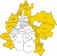
Boundaries between D.F. in white and Estado de Mexico in Yellow

I downloaded the information from the Preliminary Electoral Results Program that the Federal Electoral Institute provides online to anyone that wishes to download this information. The numbers that I present here are not to be taken as official since they come from this preliminary results system. I focused on the results of the presidential elections because they are they most controversial of elections and the ones where voters are actually familiar with the candidates. 

I prepared these maps aggregating the results from district level information into municipalities as I was unable to obtain the electoral cartography in time. The first map presents the absolute winner of the elections in each administrative area of Mexico's metropolitan area. You can observe that most of the Federal District plus the municipalities of Izcalli, Coacalco and Cd. Nezahualcoyotl form the State of Mexico favored the PRD candidate while no municipality in D.F. voted for the PRI and most State of Mexico municipalities except the other three did vote for Peña Nieto. It is important to note that the municipalities that did vote for Peña Nieto are very diverse in their demographic information. Naucalpan de Juarez in the center-west is one of the municipalities with highest income per capita in Mexico while Chimahuacan in the extreme East of the city is one of the most densely and poorest municipalities in the urban areas of the country. In the following maps I will try to dis-aggregate the presidential election results to explore on differences in the preferences of the population.


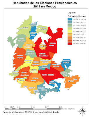
It is important to start with a quick view at the absolute voter numbers. You can observe from the map that winning certain municipalities can be more important in terms of number of votes than others. We should keep in mind these municipalities as we move on with the analysis. Iztapalapa, Gustavo Madero and Ecatepec are the areas with most population, followed by Cd. Nezahualcoyotl, Naucalpan and Alvaro Obregon.


So what can this way of looking at the information add to our current understanding of the city? Taking  the boundaries of the city as the definition you can observe in my analysis. The PRD obtained 45.15% of the votes, the PRI 32.7% and the PAN 18.11%. The Partido Nueva Alianza got 2.08% of votes and 1.85% of voters nullified their ballot. All in all 65% of the population in the electoral list went out to vote in what is considered the most participated elections in Mexican democracy. Let's start our exploratory analysis with the PRD.


The most obvious pattern to observe is that municipalities in the Estado de Mexico show a much lower fraction of the votes than within the Distrito Federal even in the municipalities where the PRD was victorious such as Cd. Nezahualcoyotl in  the East, let's call this the North-South divide. The second interesting pattern to observe is that there seems to be an West- East Divide thant comes after the North-South divide. Within the D.F. some municipalities voted for the PRD in fraction of more than 51%, Iztapalapa, Gustavo Madero, Tlahuac and Xochimilco while other municipalities in the west of the D.F. received much less votes for the PRD such as Miguel Hidalgo, Cuauhtemoc and Alvaro Obregon. This West- East divide could be related to the huge differences in income per capita in these areas. Further analysis would be required but this is one of my hypothesis. I worked in Car Market analysis and this divide shows the same pattern that the analysis of who buys new cars and who buys used cars. An interesting outlier is the Benito Juarez municipality in the center of the D.F., this area has the highest human development indicator values of the whole country. Only 39 % of votes for the PRD.

This West-East divide is also to be observed in the State of Mexico, Cd. Neza, La Paz, Chalco and Ecatepec gave the PRD 40% of their votes while Naucalpan, Tlanepantla and Atizapan only gave 32%. My hypothesis are similar than previously. But I do want to point out at one thing. How come that in Benito Juarez the PRD only got 39% and yet it won the area and in Chalco and La Paz the PRD got more than 40% and yet loss to the PRI. I hope this seems intriguing to you.

Now the PRI results. They received an average of 32.17%.


I find this map truly flabergasting, I was expecting to see similar results than the ones on the PRD, yet they are extremely different. First things first, the North South divide. Yes there are huge differences between D.F. and State of Mexico, this is familiar territory. But where is your West-East divide? Completely gone... In both the D.F. and the State of Mexico. Naucalpan a very high-income area and Cd. Nezahualcoyotl home to some of Mexico city worse slums gave a very similar amount of votes --- relatively speaking --- to Peña Nieto. In the D.F. Miguel Hidalgo (Polanco is here), Cuauhtemoc (Tepito is here) and Venustiano Carranza (home to the Airport) gave very similar results in terms of PRI fractions. Benito Juarez, Gustavo Madero and Xochimilco gave the same number of votes to the PRI. The only pattern that you might be able to talk about is some sort of North South divide within the D.F. but it is definitely not clear at all. What is true is that Iztapalapa, Coyoacan and Tlalpan are the areas where the PRI scored the lowest and it does not correspond exactly to the areas where the PRD scored highest. We are missing our third runner of the evening. 

The PAN, the right wing party, who managed to loose all municipality governments in the D.F. except for Benito Juarez. Some speak that these disastrous results are related to a very poor choice in their candidate for the government of the city. But Politics is for politicians and I am more interested in facts derived from quantitative analysis. 
When I first saw this map I actually decided that I had to write this post. I was expecting to see either of the previous two patterns that we observed for the PRD and PRI results, and here a third completely new pattern that actually made sense after a while. The North South divide in the results of the PAN are gone. There is very little difference in the results in the State of Mexico and in the D.F. Miguel Hidalgo, Naucalpan and Atizapan are all around 24%. Iztapalapa and Chalco are both 12%. Ecatepec and Gustavo Madero are close to 15%. What is really striking is the West- East divide that becomes much more noticeable than in the previous maps. Alvaro Obregon and Azcapotzalco who were sort of middle ground in their preferences to the PRD are now clearly similar to their surrounding municipalities. It is important to mention that the North-South divide in the Eastern part of the city does exist. the South East and North East are different in their PAN preferences. Yet the borders between D.F. and State of Mexico appear to have nothing to do with this.

Now these results are basically based on pure observation, they are affected by my own subjectivity and do not look into the statistical significance of the differences I mention. There are better geo-statistical analyses that are much more precise and that would yield more robust results. Nevertheless I could not have released them in such short notice. I do believe that if I performed these analysis such as cluster/hot spot analysis, run a k-means algorithm and check for statistical differences between the resulting areas and of course some local autocorrelation I would be able to support my hypothesis of the existence of this North South and West_East divide that affects differently the three political parties. The reasons for these divides remains to be explained, I believe the West-East divide is related to income while the North South divide has to do with matters related to historical governance.

In case you are interested I present the results for the PANAL a minor party that represents the teacher union which is very strong in Mexico. Here the difference between D.F. and State of Mexico is clearly noticeable. Miguel Hidalgo, Benito Juarez and Coyoacan show particularly low support for the PANAL, it would be interesting to see why that is. My guess: it's related to the number of years of education.

The patterns of vote nullification is unclear, I would throw a huge hypothesis that there are several factors involved, one is the urban rural divide, second is the number of years of schooling and third a sentiment of belief in the Mexican party system.

On participation in the elections, the differences between D.F. and State of Mexico are only noticeable in the East of the city. the West-East divide is again there. I would dare to say that the pattern I observe here is similar to the results of the PAN.
 I would be interested in performing this analysis at the section level, I am looking for the electoral cartography of Mexico and as soon as I manage to obtain it I would like to perform more in-depth statistically robust analysis of electoral preferences in Mexico at the national level.

Any suggestions or comments are greatly appreciated.


jueves, 5 de julio de 2012

Geographical diversity in Mexico's presidential elections.

On Sunday, Mexico elected its new president for the period 2012 to 2018. Enrique Peña Nieto obtained 38.14% of the votes, making him --- still to be confirmed officially --- the new president of the United States of Mexico. The leftist candidate and front-runner Obrador (A.K.A AMLO) obtained 31.64% of the votes, loosing the presidential elections for the second time after he was less than 0.5 points from the Right Party (PAN) current president Felipe Calderon back in 2006. In what was the Mexican elections with the most participation in the history of mexican democracy (63.14% of participation), Mexicans punished the poor performance of the PAN in the past 12 years in their holding of the executive power that includes 60,0000 dead. Mexicans welcomed back the PRI who was ousted unceremoniously from the Pinos (the equivalent of the white house in Mexico) in 2000 after 71 years of authoritarian rule that was plagued with violation to human rights --- including the masacre of students in 1968 --- corruption and abuse.

Enrique Peña Nieto represents the new PRI, "It is Mexico's undisputed master of political marketing: young, handsome, successful" mentions the german newspaper Die Zeit in its portrait of the new Mexican president. In his acceptance speech, Peña Nieto asked Mexicans to forget political differences and to work together for the future of the country. The extremely mediatic event where he and his wife --- a beautiful soap opera actress that probably helped Peña win the hearts of sufficient Mexicans to beat his two main contestants --- thanked those who voted for the PRI and made a commitment to rule the country responsibly was also the place where I saw the following sentence: "Today Mexico won, Mexico has decided".

My immediate question was actually what Mexico chose him? Who actually helped Peña to beat his opponents? In one article it was reported that Peña was particularly popular in the social segments of women, the older than 30 and people from rural settings and particularly unpopular in the segments of young voters and those with more years of education, who actually voted more for AMLO.

 I spent Sunday night following the PREP system that showed the counting of the votes as they arrived from the voting sections. Google built a real-time system that allowed not only to monitor the election results at the national and state level, but also gave the results at the district level. I was really surprised to see this google tool and even more interested in looking at the geographical patterns of the election. 


The results show that electoral preferences are very different across the country. In the North -West and the Bajio where the PAN has always been strong, electors still preferred Josefina Vasquez Mota to be their first female president. In the North-East, the Pacific Coast and even in the extreme South and the Peninsula the PRI was favored. In the South of Mexico, from the capital to the southern states of Oaxaca, Tabasco and even Quintana Roo, Mexicans preferred to vote for the leftist candidate.

Today I stumbled on the following image on facebook and found it quite funny. The image uses part of the history from the Lord of the Rings fantastic realm created by Tolkien to show the important diversity in electoral preferences. Although the image was probably made by individuals who did not adhere to the PRI proposal and probably dislikes USA foreign politics in Mexico, I think it is quite creative. Perhaps the image, by comparing PRD winning states with Rohan and PAN winning states with Gondor , is hinting at the necessity of PRD and PAN followers to unite if they really want to oust the PRI from power. This will have to wait until 2018...


 In the meantime I wanted to show the differences of these 2012 elections from the 2006 presidential elections. At that time the PAN won the elections by a difference of only 0.5%. The country was clearly split in only two. A clear North-South divide that has clearly changed in the last elections. Beside the clear shift of the Northern states to favor the PRI there are some interesting changes to note. Chiapas did not favor the PRD and voted for the PRI, same thing in Campeche. Puebla a state that usually has been related to conservative trends voted to the left this time. Veracruz voted mainly for the PAN in these elections.

In a deeper analysis of geographical patterns of votes it is interesting to observe certain interesting facts.

1- In some states preferences were homogeneous.

a) PRI

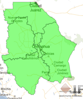
Chihuahua


Zacatecas

Michoacan
Nayarit
Sinaloa
Merida
Although most of these states are in the North-East, Merida and Michoacan are some outliers from the mix.
b) PRD


Tabasco
Oaxaca
Quintana Roo
Distrito Federal - Southern Mexico City


Some states in the South voted homogeneously for the left, in particular southern Mexico City/ D.F. the capital of the country with over 8 Million inhabitants and around 5 Million voters (out of an electorate of 49 Million). This hints at the satisfaction of people in the capital of their PRD rule since 1997. A first interesting question is how come Merida is complete and absolutely decided for the PRI and Quitana Roo completely and absolutely decided for the PRD when they are contiguous states. What makes these two places so different in their electoral preference?

2- An Urban- Rural divide.

a) PAN in the cities, PRI in the rural areas


Coahuila
Guanajuato

Sonora
Queretaro
San Luis Potosi


Although Queretaro, Coahuila, Sonora and San Luis Potosi showed dominance by the PRI, when you look into the details you can see that the big cities in these states actually voted for the PAN. Queretaro City, San Luis City, Hermosillo, Saltillo and Torreon actually voted for the PAN, it was their rural or and smaller city counterparts that actually changed the balance of the elections. In Guanajuato the pattern is similar, people in Leon, Celaya, Salamanca and San Miguel de Allende voted for the PAN and the rural parts of the state voted for the PRI. In this case the PAN won the state probably because there are more larger cities than in the other states of the center of the country.

b) PRD in the cities, PRI in the rural areas
Tijuana
Puebla
Chiapas
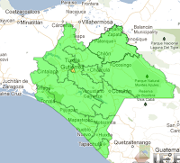
In Chiapas, Puebla and Tijuana people in the major cities voted for the PRD. It is quite surprising to see that Tijuana City and Puebla City were actually for the left party. To my best understanding these cities had been supporting other parties in the past. Another big surprise was to see the state of Chiapas, the state with the highest proportion of indigenous populations and home to the Zapatista movement to vote for the PRI this time. Tuxtla Gutierrez, the capital of the city actually voted for the PRD. Again seeing the results in Oaxaca, Guerrero, Tabasco and Quintana Roo it is quite surprising that Chiapas voted for the PRI. I would really be interested to see what happened at the Section level.

3- Estado de Mexico - PRI domination except in the areas closest to the D.F.

Estado de Mexico - Northern Mexico City
 It is quite interesting to see that although most of the Estado de Mexico voted for the PRI --- Peña Nieto was the governor of the state the last 6 years --- some of the most populated areas in the country and part of the urbanized area of Mexico City actually voted for the left. Cd. Nezahualcoyotl the municipality with most population in the country and population densities in the top 20 most densely populated areas of the world clearly voted more as a D.F. Delegation than as a Estado de Mexico Municpality. This type of analysis clearly indicates that the Estado de Mexico and D.F. borderas should probably be reanalized. Ecatepec, Cd. Neza, Chimalhuacan, Chalco, Izcalli, Tlanepantla and Coacalco might prefer to be part of the D.F.
4- Guadalajara - a small drop of blue in a green ocean

Guadalajara
 I was very surprised to see that Jalisco, the state that host Guadalajara ---  the second city with more population in the country --- actually had voted for the PRI. Almost... A small area in the state, in the upper north-west of the city. An area called Zapopan, and also part of the center of Guadalajara City remained loyal to the PAN.

Basically the population with the highest income stayed with the PAN and the rest voted for the PRI. This hints at another trend in voter preferences. Urban/Rural, Income, Historical preferences are some of the aspects we have observed until now.

5- Monterrey - Almost loyal to the PAN

Monterrey
Monterrey, the third city in population size and the closest to the USA of the main cities in Mexico, remained loyal to the PAN. 

There is one municipality in the urban are that voted for the PRI though. I am intrigued by this municipality where Peña got 40% of the votes whereas the PAN only got 29%. 

The trend in the other municipalities was PAN 45% PRI 30%. 

It would be interested to see what demographic characteristics explain this difference.


5- An interesting case of electoral diversity - Veracruz

In Veracruz you can actually see many of the differences we saw in other areas of the country. Rural areas voted for the PRI, a North South divide. Xalapa, a student city sometimes called the Mexican athens voted left. The Veracruz city port voted right and Cd. Madero and Tuxpan in the North voted PRI. The results in Veracruz would probably be the motive of a very interesting paper on electoral diversity in Mexico. I would really like to learn more about the reasons for the electoral diversity in this state.

To conclude with this post, it seems that the diversity in electoral preferences hints at a more mature democracy in Mexico. It also hints at the diversity in the population. I hope our new president Enrique Peña Nieto keeps this in mind in his next 6 years of ruling the country. I hope when he says Mexico won he doesn't believe that all of Mexico elected him... I hope he means this as the fact that Mexico won because we are truly entering a democratic era. I hope the old ways of the PRI are not used again, I hope repression, authoritarian rule and corruption will not come back with the PRI. Enrique Peña Nieto ,welcome to the presidency, we hope Mexico moves in the right direction with you... We really need it...